APPLICATION OF AUGMENTED REALITY TECHNOLOGIES IN ARCHAEOLOGY
APPLICATION OF AUGMENTED REALITY TECHNOLOGIES IN ARCHAEOLOGY
S. Vedat KARAARSLAN
Electronics Eng. (MSc.) - Archaeologist
ABSTRACT
Museums and registered open or closed sites are the places that collect, document, display and preserve the creations of art and science where the individuals of society can learn, research and make connections between today, past and future. These museums and sites are improving with the developments in technology, enabling visitors to experience more by using online interactive applications. Contrary to the inert, one-sided flow of information model, Interactive museum model can inspire visitors with concepts of curiosity, option, cooperation, creativity and discovery like in a game (Beale, 2011). Augmented Reality (AR) enhances our pysical enviorenment with digitally crafted audio, graphics and real-life objects by using eihter monitors or 3D Virtual Reality Headsets, using AR with this purpose supports processual archaeological approaches (Clark and Binford, 1982). With this technology it is possible to introduce the visitors of museums and sites to enhanced visuals of real archaeological artifacts and features, wireless and real time with the help of global positioning satellites. The presentation will evaluate on how to use AR technologies in museums and sites, and discuss the topology of network infrastructure.
Keywords: Augmented Reality, archaeology, museum, computer
INTRODUCTION
ICOMOS (International Council on Monuments and Sites) ensured that cultural inheritance based on archaeological information could be gained by scientific research and by non-destructive sampling methods in excavation site. As well as the protection of the cultural inheritance is provided with Information Technologies, not only the evaluation and interpretation of desktop information are important as the conventional interpreting method but also the new trend known as “hypothetical” or “post-processual” has gained importance in terms of the computerization of archaeology and cognitive archaeology. The definition of archaeology and its relationship with technology in this development process is shown on the Table 1 above from the year 1930 until today.
In these periods, today archaeology has reached its cognition/perception archaeology stage; and within the scope of information technologies it is supported with the studies in the field of artificial intelligence, geographical information systems, modeling and simulation, visualization and webography; with evaluation of surface research and excavation context data it provides technological and visual convenience for presenting to visitors of museums and in situ archaeological sites.
Foremost among these technologies by using modeling can be listed as computer simulations (FUGAWILAND, WINDIGFREWARE, SV-GASMP, ARCDIG etc.) Virtual Reality, Ethnoarchaeology with Motion Capture that is same as the reality and being able to record the movements of humans, animals and plants, collecting data on the topography of the surface of the earth via satellites, Remote Sensing to search the surface with locating coordinates, Laser Scanning on the LASER band as scanning aerial or close, Satellite, HAP (high altitude platform), Infrared Photography with planes or balloons (INFR), Archaeoacoustics to collect data on the lives of the civilizations in Ancient Age via audio applications and Augmented Reality (AR) with computer simulations with natural environment and human (Tom Caudel, Boeing, 1990).
In this paper, the ways to use Augmented Reality (AR) in archaeology, the examples from the world and new projects to be executed will be discussed and investigated.
AUGMENTED REALITY TECHNOLOGIES (AR)
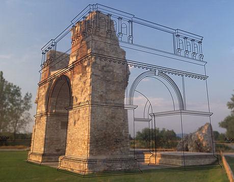
By adding objects such as 3-D model as real-time, animation, film, audios an item which is wanted to be interacted with AR defined as enriched, is got in touch with physical world via different platforms like smart phones, web-cams or screen. (Tom Caudel, Boeing, 1990) The created image is shown as if it is in the physical world by overlapping the animated images with the real world to be presented to the audience. It is foreseen that the number of telephones that are equipped with AR technologies known as printed media platform, recording, cinema, radio, television, internet and mobile phones will be over one billion in the whole world onwards the year 2020.
In in situ findings, by adding objects such as 3-D model as real-time, animation, film, audios on any image, an item which is wanted to be interacted with a platform defined as enriched, is got in touch with physical world via different platforms like smart phones, web-cams or screen by locating coordinates found by GPS data. This created image is shown as if it is in the physical world and is presented as a real world to the users when they wander about the platform via 3-D visualization, network platform. Usage of AR in archaeology is based on the principle of presenting to the audience the images that are digitized as animation – 3-D images that are created by technical staff who write software programs according the scenarios determined by archeologists about the original images of archaeological sites to be viewed or monuments in museums and their states in the era that they belong to.
CREATING ARCHAEOLOGICAL DATA
Archaeological Data management starts with digitizing for archiving, visualization, accessible maps and 3D images, thematic interactive access models and identifying interface program that combine these models with images. It should be foreseen that the documentation is written as text and text to speech. Use of database that is compatible with XML software suggested by WWW Consortium (W3C) enables that AR applications can be viewed on mobile phones. CIDOC CRM (International Committee for Documentation Conceptual Reference Model) that is used to identify the implicit and explicit concepts that are used in cultural inheritance documents enables to use documents on databases officially. [1] To the same extent, ISO 21127:2014 should be evaluated as an important suggestion to be applied on how to use documentations about protection of culture inheritance on databases. [2] The archaeological data is presented to the viewers as visualized with the members of archaeological sites that are in situ and museum as system management as software and filing and managers that control the application software on networks and under the supervision of these managers. Accordingly, data in the servers are turned into a catalogue and identified as stela in the sealed site, script, listing with the description of every area, themes that show the place and the era, 2D and 3D interaction, visualization of tables and data, searching (by data type, keyboard, pictures) and finally graphing functions for transition of 2D and 3D images.
For a displayed archaeological item to be uploaded to the database, first, it should be shoot as 2D, for example by a camera named Wild p31. Then, the coordinates and lines are measured manually in every image, and it is converted into an image with PhotoModeler software, DXF, VRML or 3 DS Max Studio by enumerating surface parts. The photographs of the objects are identified by PhotoModeler and the object is converted to 3D by choosing three controlling points or by using a free software as 3D. After these steps, the object is transformed to be published online. [3]
2D pictures, 3D models, audios and videos, papers about objects that are related to archaeology are uploaded to Site Information Server (SIS). The database is designed to be shown in groups as a hierarchical tree like after a main image of a temple is shown pronaos and the monuments are shown as a hierarchy. The data is provided to the system as context based according to the archaeological registrations like the names of the marble monuments after 5 B.C., their type, periods, geographical locations, category. SIS is responsible for creating, identifying and managing of the multimedia content and augmented data, a toolbar unit that enables virtual tour written with a graphic interface program (JAVA), controlling of the objects, program editor, editor for choosing options, know editor for knot of the objects in archaeological site and GIS editor.
AUGMENTED REALITY SOFTWARE AND APPLICATIONS THAT CAN BE USED IN ARCHAEOLOGY
ARCHEOGUIDE
This software was first used as a European Union with a 5 million euros budget for on-site AR applications of cultural inheritance by Italy, Portugal, [5][12] Germany and Greece in the Olympics in Olympia. The data and the aerial photographs are processed on DEM (Digital Evaluation Model) by using GIS and uploaded to databases by using VRL (Virtual Research Language) software. [6]
DGPS (Different Global Positioning System) and compass make visualization as location with “Image Tracking” software. This information transfer the 3D and the “rendered” images of buildings, objects, ruined archaeological sites and natural environment to the user. Tracking, rendering, controlling, data management and user interface programs are performed together with the users’ interaction and reading data. Here, Archeoguide software enables optimizing the scanning speed set by the user by analyzing a 2D picture in the frequency domain with an algorithm and performing a real-time interaction. During the scanning of the objects, the software transacts accordingly by evaluating the differences between pictures with mathematical approaches. (Fourier, Dirac etc.) Again, while the users are scanning the objects, if rotating and the scaling the objects or both is done, the same mathematical measurements are taken. Multimedia synchronization is performed with the applications in the program. Though 11 Mbps link speed for mobile devices and a computer with a CPU that is 800 Mhz is enough for the technological infrastructure, according to the traffic measurements it is seen possible that reaching to the server speed more than 1.5 Ghz with a computer with Pentium 4 CPU. During a test that is being carried out as communication infrastructure (300x500 meters) IEEE 802.11b WLAN access standard was used and 3 Access Points (AP) were establish in total. It was converted from 12 Volts to 220 Volts with the solar panels on AS and directive antennas with 4.4 meters’ height were used. DGPS units established for the signals to reach right locations works on a band of 300 Khz and RTCM SC-104 standards as wireless access, and they are seen with a 0.5 degree inclination by enabling verification less than 1 meter. The network infrastructure was designed with a 11 Mbps access speed that can serve 50 users at the same time. For optical monitoring to be real-time, the visual angle should be tracked well and to do this the 2D image should be scanned by the device of the user by contacting with the reference image in the servers the rendered image should be presented to the users as “augmented”. Therefore, the liability of the algorithm is crucial for the choice of recording method on the database. In terms of the positions of the shadow, cloud or sun on the image that is continuously changing in users’ hands, the choice of whether to do the recordings in dense pixels or frequency space should be done by the archeoguide program. In this study, the Fourier based approach has been chosen because of quick measuring and high-powered tracking system, the position of the image that has been augmented and the real picture between 2D and 3D shown to the user and other angular differences should be eliminated with mathematical measurements.(Vassilios Vlahakis, et al.)
LIBRESOCIAL
LibreSocial software was established in 2009 by Universidad Rey Juan Carlos with 1 million euros budget as a European Unioun FP6 FLOSS (Free/Libre and Open-Source Software). [7] With the project, statues and museums in Madrid have been taken under the scope of AR as mobile application.
ARCube
The main problem with devices that are used as web camera come in sight as negative effects on visualizing because of camera vibrations. Open-source software like ARSight [8], ArToolkit [9], BuildAR [10] cannot be used for every archaeological object (monuments, basilica, pot etc.) but all archaeological objects drawn with 3D Studio Max as plug-in work with ARCube and 3D models that cannot be drawn open to different software can be done with ARCube without vibration.
The working principle of ARCube system mehod is that controlling the image controlling the image that the length of every corner is enough for AR drawing by providing 1:1 scale image, with 1.5 meters distance, to a webcam with 2 megapixels of which 6 faces were written with A, B, C, D, E, F, G letters, as a cube 8x8 size.
Firstly, the 3D image of archaeological object is viewed on the screen. From the cube that was written with letters, and the whole object is seen by rotating the 3D object to the sides of choice.
CONCLUSION
The use of AR technology in archaeology as a method that can be used in In situ sites and museums, under the scope of the standards that were given in this paper, can be done by visualizing the images by downloading them to databases and by presenting to the users with network infrastructures in pilot archaeological sites and museums. These databases should be enriched with animations and provided with detailed information, moreover, the pages of history books that are out of reach should be digitized and made accessible to the visitors.
Under the scope of the application that is known as museum card (müzekart) in Turkey, and by giving an access password to every museum card (müzekart) to view the archaeological sites and museums with the password and building AR systems in the museums can fulfill the aims of presenting the true information to the visitors and increasing the number of users of museum card (müzekart).
|
DATE |
STAGE OF ARCHAEOLOGY |
THEORY |
HARDWARE / SOFTWARE |
AREA OF USAGE |
|
Before 1930 |
Natural Observation |
Definitional |
Calculator |
Statistical Analysis |
|
1930-65 |
Cultural History |
Geographic |
Main Computer / Cobol / Fortran |
Statistical Analysis and Data Collection |
|
1965-80 |
Processual |
Rule-bound, Systematic, Hypothetical |
Mini WAX, PC, Pascal, C, Basic |
Causative Results, Modeling and Simulation, Geographical Information Systems (GIS) |
|
1980-95 |
Theoretic (Post processual) |
Individual, Interpretative |
PC, C++, Prologue |
Expert Systems, Artificial Intelligence (AI), Excavation Site Usage, GIS |
|
1990- |
Cognition / Perception |
Experimental, Hypothetical, Restoration |
Workstations, Parallel Processors, High Performance Computing, Visualization, Middleware Languages |
AI, GIS, Modeling and Simulation, Visualization, Webography |
Table 1. Periodical Development of Archaeology
REFERENCES
[1] (http://www.cidoc-crm.org/) (http://network.icom.museum/cidoc/home/who-we-are/)
[2] ISO 21127:2014 (Information and documentation -- A reference ontology for the interchange of cultural heritage information- Document published on: 2014-10-15)
[3] Autodesk 1234D/ http://www.123dapp. com/catch
[4] http://oldsite.photomodeler.com/about_us/images/presskit/Messancy_elipsoids_Large.jpg
[5] Vassilios Vlahakis, Nikolaos Ioannidis, John Karigiannis, Manolis Tsotros, and Michael Gounaris Intracom S.A., Greece Didier Stricker Fraunhofer Institute IGD, Germany Tim Gleue and Patrick Daehne Center for Computer Graphics (ZGDV), Germany Luís Almeida Center for Computer Graphics (CCG), Portugal, Archeoguide: An Augmented Reality Guide for Archaeological Sites, Computer Graphics in Art History and Archaeology, IEEE, September/October 2002
[7] http://www.libregeosocial.org/
[8] www.arsights.com
[l1] ARCube, B. JIMÉNEZ FERNÁNDEZ-PALACIOS,F. NEX, A. RIZZI and F. REMONDINO, Optical Metrology Unit, Fondazione Bruno Kessler, Via Sommarive 18, Trento, Italy, Department of Cartographic and Terrain Engineering, Polytechnic School of Avila, University of Salamanca, Hornos , Caleros 50, Avila 05003, Spain, SMART3K S.R.L., Via Sommarive 18, Trento, Italy,
[12] www.arkeotekno.com
[13] (Picture): http://www.ezonetoday.com/2018/01/What-is-AR-Augmented-Reality-How-it-works.html
This article was accepted by CONTINUNITY & CHANGE : NEW APPROACHES TO LEGACY DATA IN ARCHAEOLOGY, APRIL 2016 , MIDDLE EAST TECHNICAL UNIVERSITY, GRADUATE PROGRAM IN SETTLEMENT ARCHAEOLOGY under the title APPLICATION OF AUGMENTED REALITY TECHNOLOGIES IN ARCHAEOLOGY and published by EGE YAYINLARI (2018)
Sayfa Yorumları (0)
Yorum Bırakın